Home » World News »
Tropics stay active in Atlantic as disturbance may develop into Isaias, setting another record
National forecast for Monday, July 27
Fox News senior meteorologist Janice Dean has your FoxCast.
An area of disturbed weather out over the Atlantic Ocean may add yet another record to a busy 2020 hurricane season.
The U.S. National Hurricane Center (NHC) in Miami said Monday that showers associated with a broad area of low pressure about 1,000 miles east of the Windward Islands is entering an area favorable for development.
"This is our next storm system that we think is going to get a name, probably tomorrow, Isaias is going to be the "I'-named storm," Fox News senior meteorologist Janice Dean said on "Fox & Friends." "We're going to have to watch the development of this system because it's going to move into the Caribbean."
ATLANTIC HURRICANE SEASON: WHERE DO TROPICAL STORMS FORM IN JULY?
According to the NHC, the system has become a little less organized since Sunday night but it is still in an area where things are favorable for development.
Over the next day or two, there's an 80 percent chance of a tropical depression or tropical storm forming.

There’s a 90 percent chance the next tropical system forms in the next 5 days, according to the National Hurricane Center.
(Fox News)
In a five-day stretch, that formation chance gets bumped up to 90 percent.
The system is moving westward to west-northwestward at 15 to 20 mph and could begin to affect portions of the Lesser Antilles on Wednesday or Wednesday night.
"Interests on those islands should continue to monitor the progress of this system," the NHC said.
HURRICANE HANNA'S 'MESMERIZING' LANDFALL IN TEXAS SEEN FROM SPACE, 'SIGNIFICANT' RAINS PRESENT FLOOD THREAT
After entering the Caribbean, all eyes are on computer models for where the system would go next.

Computer models depicting the path of the next possible tropical system.
(Fox News)
"Getting a little bit too close for comfort towards the East Coast next week," Dean said Monday. "So something we're going to have to watch. It has been a very busy tropical season thus far, and we're not even into the peak yet."

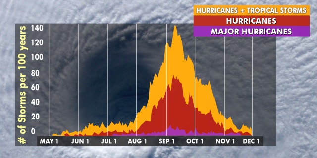
Hurricane season peaks from late August through early October.
(Fox News)
If the system develops into the named storm it will have the name Isaias and set yet another record for the earliest named ninth tropical storm, the latest of storms this season to do so.
CLICK HERE FOR MORE WEATHER COVERAGE FROM FOX NEWS
Colorado State University hurricane research scientist Phil Klotzbach said on Twitter the record for the earliest "I" storm in the Atlantic basin is Irene, which formed on Aug. 7, 2005.
On July 5, Tropical Storm Edouard become the earliest fifth-named storm on record. Tropical Storm Fay became the earliest sixth-named storm when it formed off the East Coast on July 9.
CLICK HERE FOR THE FOX NEWS APP
Meanwhile, Gonzalo set yet another record last week, continued by Hanna, which went on to be this season's first hurricane and made landfall in Texas.

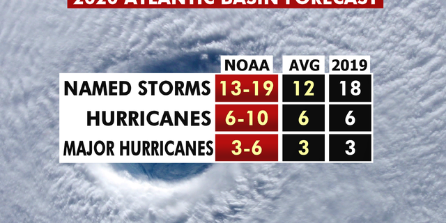
The 2020 hurricane season forecast from NOAA.
(Fox News)
While eight named storms have developed so far, forecasts call for 13 to 19 named storms during the 2020 Atlantic hurricane season, which runs from June 1 to Nov. 30.

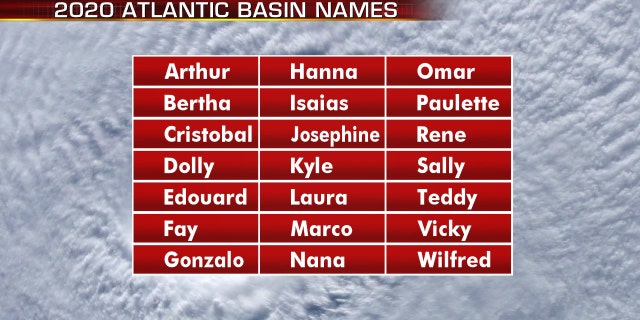
The names for the 2020 Atlantic hurricane season.
(Fox News)
The 2020 Atlantic Hurricane Season will include the names: Arthur, Bertha, Cristobal, Dolly, Edouard, Fay, Gonzalo, Hanna, Isaias, Josephine, Kyle, Laura, Marco, Nana, Omar, Paulette, Rene, Sally, Teddy, Vicky and Wilfred.
Source: Read Full Article


