Hurricane Larry is set to bring dangerous surf to US east coast
NEW YORK (NYTIMES) – Hurricane Larry churned across the central Atlantic on Monday (Sept 6) and was expected to cause life-threatening surf conditions and rip currents along the East Coast of the United States later this week, according to the National Hurricane Centre.
As of Monday afternoon, Larry was about 950 miles (1,500km) south-east of Bermuda and moving north-west at 10mph (16kmh), the Hurricane Centre said. The Category 3 storm had maximum sustained winds of 125mph.
Although there were no coastal watches or warnings in effect Monday, swells generated by Larry were already affecting the Lesser Antilles, the crescent of islands in the eastern Caribbean that curves from the Virgin Islands to Grenada.
The swells were expected to spread west by Tuesday and could reach the United States and Canada by the middle of the week, the Hurricane Centre said.
Larry, which became the 12th named storm of the 2021 Atlantic hurricane season last Wednesday, intensified to a Category 3 hurricane Friday, when Mr Dennis Feltgen, a meteorologist and spokesman for the Hurricane Centre in Miami, said it was “not forecast to strike the United States.”
Mr Feltgen said this hurricane season, as expected, had been an active one, but that there was “a long way to go.”
The peak of the season runs from mid-August to late October, and maximum activity takes place in early to mid-September, he said.
It has been a dizzying few weeks for meteorologists who have monitored several named storms that formed in quick succession in the Atlantic, bringing stormy weather, flooding and damaging winds to parts of the United States and the Caribbean.
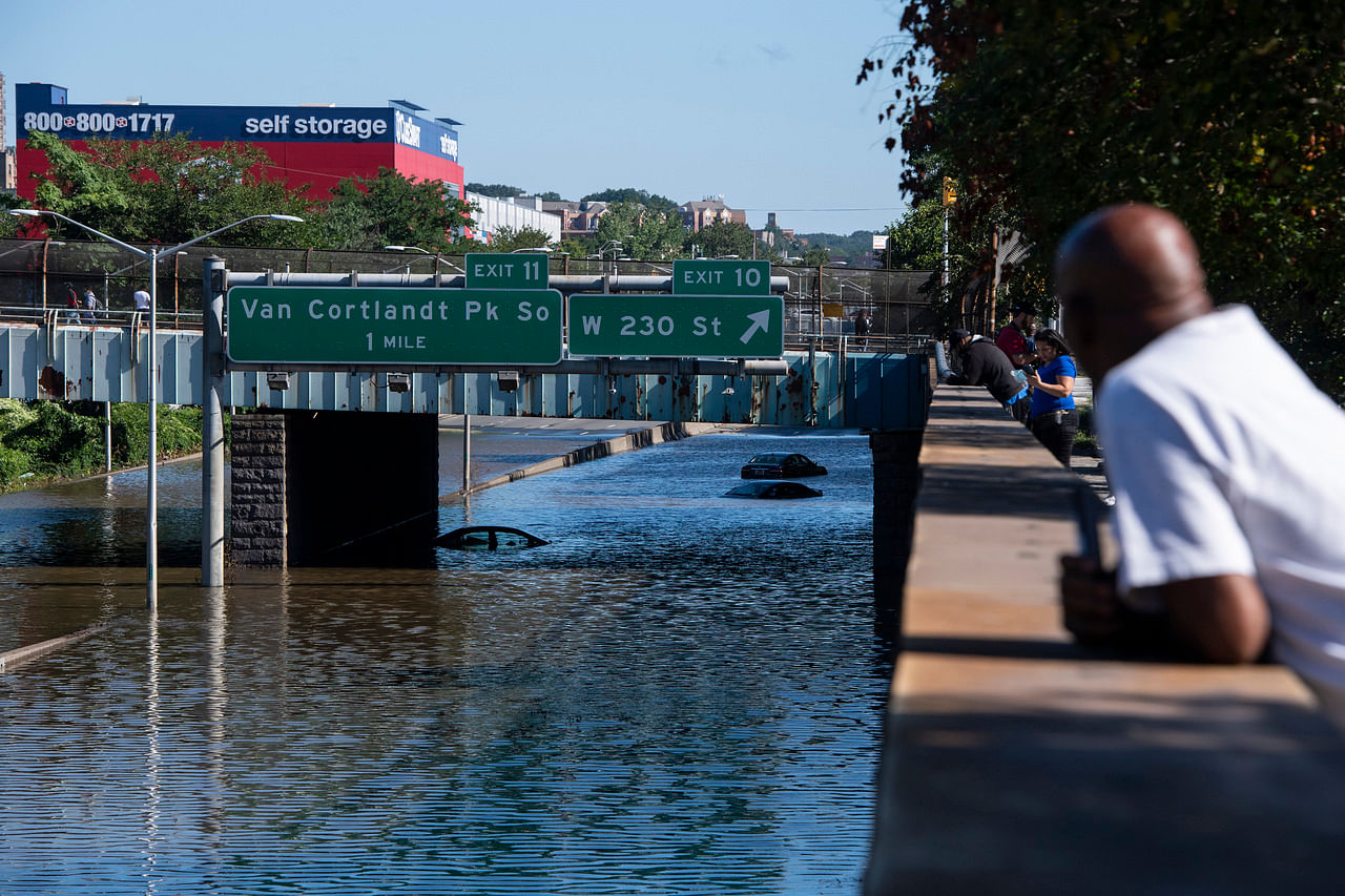
In addition to Ida, which battered Louisiana as a Category 4 hurricane on Aug 29 before its remnants brought deadly flooding to the New York area, there were also Julian and Kate, both of which quickly fizzled out within a day.
Not long before them, in mid-August, Tropical Storm Fred made landfall in the Florida Panhandle and Hurricane Grace hit Haiti and Mexico.
Tropical Storm Henri knocked out power and brought record rainfall to the northeastern United States on Aug 22.
The quick succession of named storms might make it seem as if the Atlantic is spinning them up like a fast-paced conveyor belt, but their formation coincides with the peak of hurricane season.
The links between hurricanes and climate change are becoming more apparent. A warming planet can expect stronger hurricanes over time, and a higher incidence of the most powerful storms – though the overall number of storms could drop, because factors like stronger wind shear could keep weaker storms from forming.
Hurricanes are also becoming wetter because of more water vapour in the warmer atmosphere. Scientists have suggested storms like Hurricane Harvey in 2017 produced far more rain than they would have without the human effects on climate. Also, rising sea levels are contributing to higher storm surge – the most destructive element of tropical cyclones.
A major United Nations climate report released in August warned that nations have delayed curbing their fossil-fuel emissions for so long that they can no longer stop global warming from intensifying over the next 30 years, leading to more frequent life-threatening heat waves and severe droughts.
Tropical cyclones have likely become more intense over the past 40 years, the report said, a shift that cannot be explained by natural variability alone.
Ana became the first named storm of the season on May 23, making this the seventh year in a row that a named storm developed in the Atlantic before the official start of the season on June 1.
In May, scientists with the National Oceanic and Atmospheric Administration forecast that there would be 13-20 named storms this year, 6-10 of which would be hurricanes, including 3-5 major hurricanes of Category 3 or higher in the Atlantic.
NOAA updated its forecast in early August, predicting 15-21 named storms, including 7-10 hurricanes, by the end of the season on Nov. 30.
Last year, there were 30 named storms, including six major hurricanes, forcing meteorologists to exhaust the alphabet for the second time and move to using Greek letters.
It was the most named storms on record, surpassing the 28 from 2005, and the second-highest number of hurricanes.
Join ST’s Telegram channel here and get the latest breaking news delivered to you.
Source: Read Full Article