Flooded New Orleans braces for possible hurricane
A slow-moving storm is forming into a likely hurricane in the Gulf of Mexico, and is forecast to hit the already-flooded US city of New Orleans.
The storm, which is currently classified as a tropical storm, has already brought thunderstorms to the city, triggering flash floods.
A state of emergency is in effect and residents in some low-lying areas have been asked to evacuate.
The river may come dangerously close to overtopping levees shielding the city.
The Mississippi River may rise as high as 20ft (6m) above sea level, officials warn, potentially exceeding the 20-25ft levees protecting New Orleans.
“We’re confident the levees themselves are in good shape. The big focus is height,” Ricky Boyett, a spokesman for the US Army Corps of Engineers, which maintains the fortifications, told the AP.
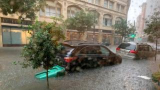
Flash flooding
On Wednesday morning, the New Orleans metro area was hit by as much as eight inches of rain over a three hour period.
Swamped streets saw rubbish bins overturned and vehicles flooded. Some parts of the city saw streets turn into lakes as deep as four feet. Kayakers were seen paddling on roadways.
The National Hurricane Center said on Thursday morning that the storm was 95 miles south-east of the mouth of the Mississippi River, with maximum sustained windspeeds of 40mph (64 km/hr).
The tropical storm has been given the name Barry by US weather forecasters.
At winds of 74mph it will be declared a hurricane, as it is forecast to become before making landfall in the delta of the Mississippi River on Friday.
The storm is predicted to drop 10-15 inches of rain on Friday and Saturday along the Louisiana coast and parts of Texas.
Update: Here are the 10 AM CDT Key Messages on Tropical Storm #Barry, expected to bring dangerous storm surge, wind and rainfall impacts to portions of the Gulf Coast. See https://t.co/tW4KeFW0gB and https://t.co/SiZo8ohZMN for more information. pic.twitter.com/njn6ty8FLV
End of Twitter post by @NHC_Atlantic
Residents have been warned to stock up on drinking water and non-perishable food, as well as other emergency supplies.
Plaquemines Parish, south of New Orleans, has ordered residents to evacuate. Vermilion Parish, to the west of the city, has asked some people living in low-lying areas to consider moving to higher ground.
Storm surges are expected to see rivers and tides crest at levels far higher than average, officials warn.
The primary danger is in the amount of water from surges and rainfall, according to emergency responders, rather than wind damage.
Tropical Storm Barry is currently “moving very slowly to the west at 5mph” the National Weather Center warned in an advisory on Thursday.
The National Hurricane Center warns that the storm may produce tornados along southern portions of Louisiana and Mississippi.
6+ inches of rain in under an hour = stranded on my way to @WWNO.
But at least people were taking it in stride … kayaks and free daiquiris pic.twitter.com/6QXSA7Ruzx
End of Twitter post by @Patrick_Madden
Officials warn that even if the storm does not form into a hurricane, heavy rain could still create dangerous conditions lasting for days.
“No one should take this storm lightly,” said Governor John Bel Edwards as he declared a state of emergency.
“As we know all too well in Louisiana, low intensity does not necessarily mean low impact.”
Source: Read Full Article